Hidden Gems of the Pacific Coast Highway: A 7-Day Road Trip Guide

What Are the Best Stops Along the Pacific Coast Highway?
The Pacific Coast Highway—California's legendary Highway 1—delivers dramatic cliffs, hidden beaches, and charming coastal towns that transform an ordinary road trip into something extraordinary. This 7-day itinerary covers roughly 600 miles from San Francisco to San Diego, skipping the obvious tourist traps in favor of stops that reward curiosity. You'll find sea caves accessible only at low tide, mom-and-pop seafood shacks with century-old recipes, and campgrounds perched above the Pacific where the ocean soundtrack comes free.
Here's the thing: most PCH guides recycle the same five attractions. (Monterey Aquarium is great—but you already knew about it.) This route prioritizes lesser-known gems while still hitting a few iconic spots worth the crowds. Pack layers. The coast can shift from foggy 50s to sunny 70s in an hour.
Days 1-2: San Francisco to Big Sur — Where the Cliffs Meet the Fog
Start early. Traffic leaving San Francisco stacks up by 9 AM, and you'll want clear skies for the first major stop: Pigeon Point Lighthouse. It's 50 miles south of the city, and the 115-foot tower (tallest on the West Coast) anchors a quiet state park with hot springs-fed showers—rare luxury for a $10 day-use fee.
The catch? Highway 1 narrows to a winding two-lane past Santa Cruz. Take it slow. Stop at Swanton Berry Farm for organic strawberry shortcake and an old-school honor-system farm stand. The berries taste different here—smaller, concentrated, like someone turned up the flavor dial.
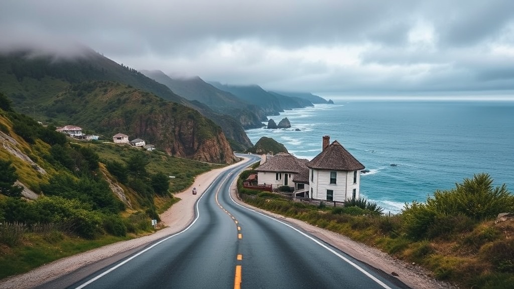
By afternoon, you'll hit Big Sur. Skip the packed McWay Falls overlook at midday. Instead, book a site at Kirk Creek Campground—perched on a bluff 100 feet above the ocean, sites 1-7 face west for sunset views that'll ruin you for other campgrounds. (Arrive by 2 PM. These spots fill by Thursday for summer weekends.)
Hike the Ewoldsen Trail at Julia Pfeiffer Burns State Park. It's a 4.5-mile loop through redwood canyons with fewer crowds than the coastal trail. For dinner, Nepenthe serves overrated $24 burgers. Drive 10 minutes south to The Sur House instead—better cocktails, local artichokes, and no gift shop.
What's the Most Scenic Drive on the Central Coast?
The stretch from Big Sur to San Simeon rivals any coastal road on Earth. Depart Kirk Creek at sunrise—the morning light hits the Santa Lucia Mountains at an angle that turns the ridges gold and violet. Stop at Bixby Creek Bridge for photos, but don't linger. Better views await at Garrapata State Park, where a half-mile trail drops to a beach where sea otters raft in the kelp beds.
San Simeon gets a bad rap as "that place with Hearst Castle." (The castle is worth skipping unless you're into gold-plated pools and gaudy antiques.) The real draw? Elephant Seal Vista Point. From December through March, thousands of elephant seals crowd the beach—bulls fighting, pups nursing, the whole chaotic spectacle visible from a wooden boardwalk. Even in off-season, a few hundred lazy males lounge like overstuffed sausages.
For lunch, Sebastian's General Store in San Simeon serves tri-tip sandwiches that justify the detour inland. The building dates to 1852, and the wood-fired smoker out back hasn't changed in decades.
Push south to Morro Bay for the night. The Morro Bay State Park campground sits across the bay from the famous Morro Rock—a 576-foot volcanic plug that dominates the horizon. Kayak rentals at Morro Bay Paddlesports run $35 for two hours. Paddle the estuary at high tide when the water's calm enough to spot bat rays and sea lions.
Where Should You Stop Between San Luis Obispo and Santa Barbara?
This section often gets rushed. Don't make that mistake. San Luis Obispo—SLO to locals—ranks among California's most livable small cities. Thursday night farmers market on Higuera Street shuts down six blocks of traffic for fresh oysters, street tacos, and surprisingly good local wine. The Madonna Inn nearby offers gaudy themed rooms (the Cave Room has actual rock walls) if you want a memorable splurge.
South of SLO, the highway hugs the coast through Pismo Beach. Skip the tourist-trap pier. Instead, drive onto the sand at Oceano Dunes State Vehicular Recreation Area—the only California beach where vehicles can legally drive on the sand. Rent a dune buggy from Sun Buggie Fun Rentals ($85/hour) or just cruise the beach in your own 4WD. It's silly. It's loud. It's genuinely fun.
The stretch through Lompoc surprises first-time visitors. This agricultural valley produces more flower seeds than anywhere in the world—billboards of blooming fields explode with color June through August. Stop at La Purisima Mission for a self-guided tour of the most fully restored Spanish mission in California. The living history demos (blacksmithing, candle-making) run most weekends.
Santa Barbara deserves two nights. Base at Carpinteria State Beach—18 miles south of downtown, quieter than city beaches, with excellent tidepooling at the nearby seal rookery. The campground fills fast; reserve through ReserveCalifornia months ahead for summer.
Days 6-7: Malibu to San Diego — The Southern Stretch
Leaving Santa Barbara, Highway 1 technically ends at Oxnard—but most drivers continue on the Pacific Coast Highway through Malibu. This is celebrity-spotting territory, sure, but also home to El Matador State Beach. A steep staircase drops to sea caves, rock arches, and tide pools packed with purple sea urchins and orange starfish. Visit at low tide (check NOAA tide tables) when the caves open for exploration.
Malibu seafood options range from $200 omakase to paper-plate fish tacos. Malibu Seafood—perched above the Pacific Coast Highway with picnic tables and ocean views—serves the latter done right. Order the fish and chips, grab a bench, watch the surfers at First Point.
Santa Monica marks the end of the wild coast. Traffic bottlenecks here—expect 90 minutes to reach San Diego if you leave after 2 PM. The solution? Detour inland on I-5, then cut west at Dana Point for the final stretch.
San Diego offers proper campgrounds at Campland on the Bay—a massive operation with full hookups, kayak rentals, and weekend concerts. It's not rustic. (You'll hear generators.) But after six days of cliffside camping and bucket toilets, hot showers and ice cream shops feel earned.
Camping Comparison: Where to Sleep
| Campground | Price/Night | Best For | Booking Window |
|---|---|---|---|
| Kirk Creek (Big Sur) | $35 | Ocean views, isolation | 6 months ahead |
| Morro Bay State Park | $45 | Kayaking, families | 2 months ahead |
| Carpinteria State Beach | $50 | Tidepools, near Santa Barbara | 3 months ahead |
| Campland on the Bay (San Diego) | $85+ | Amenities, RV hookups | 1 month ahead |
What Should You Pack for a Pacific Coast Highway Road Trip?
Layering isn't optional—it's survival. Morning fog rolls in thick, burns off by noon, then the wind picks up by 4 PM. Pack a Patagonia Houdini jacket (windproof, packs to fist-size), wool base layers, and one warm fleece. The coast rarely hits 80 degrees, even in July.
Bring binoculars. Whale watching from Highway 1 pullouts requires zero boat ticket—gray whales migrate December through April, blues and humpbacks show up summer through fall. A $50 pair of Celestron Nature DX 8x42 bins outperforms phone cameras for spotting spouts.
For the car: a physical cooler (electric coolers drain batteries), offline maps downloaded to Google Maps (cell service dies for long stretches), and cash for the honor-system farm stands. Download podcasts—Wait Wait... Don't Tell Me archives work for cliffside drives when radio turns to static.
Camping gear depends on your stops. Kirk Creek has windbreaks but no protection from coastal gusts—bring a tent rated for three seasons minimum. The REI Co-op Trailmade 2 handles Big Sur's 30-mph evening winds without flapping. A Therm-a-Rest NeoAir XTherm pad insulates against ground cold that seeps through summer nights.
The Pacific Coast Highway rewards slow travel. Rushing through misses the point—it's not about covering miles. It's about pulling over at random vista points, following hand-painted signs to "fresh crab," watching the fog roll through cypress trees while drinking bad coffee from a gas station thermos. Seven days gives enough time to stop being a tourist and start feeling like a local. The highway's been here since 1934. It'll wait while you figure out where you want to be.